
Take a look at a state map. Why is Virginia shaped the way it is?
Part of the answer is geographical: The Potomac River makes a pretty good natural boundary with Maryland.
Part of the answer is political: The southern border with North Carolina is a straight line because that’s how it was drawn by surveyors back in Colonial times.
Part of the answer is rooted in antiquated modes of transportation: The Eastern Shore seems disconnected now, but back when travel by boat was faster than by horse, those counties across the Chesapeake Bay seemed pretty close.
Look at any other state, and the details may vary, but the general themes remain the same: Other than Alaska and Hawaii, state lines got drawn by a complicated mix of politics, geography, and local quirks. Here’s a quirk: Michigan and Ohio called out their militias in 1835 over who should get Toledo.
People are also reading…
Now let’s engage in a thought experiment: What if state lines were drawn along economic lines?
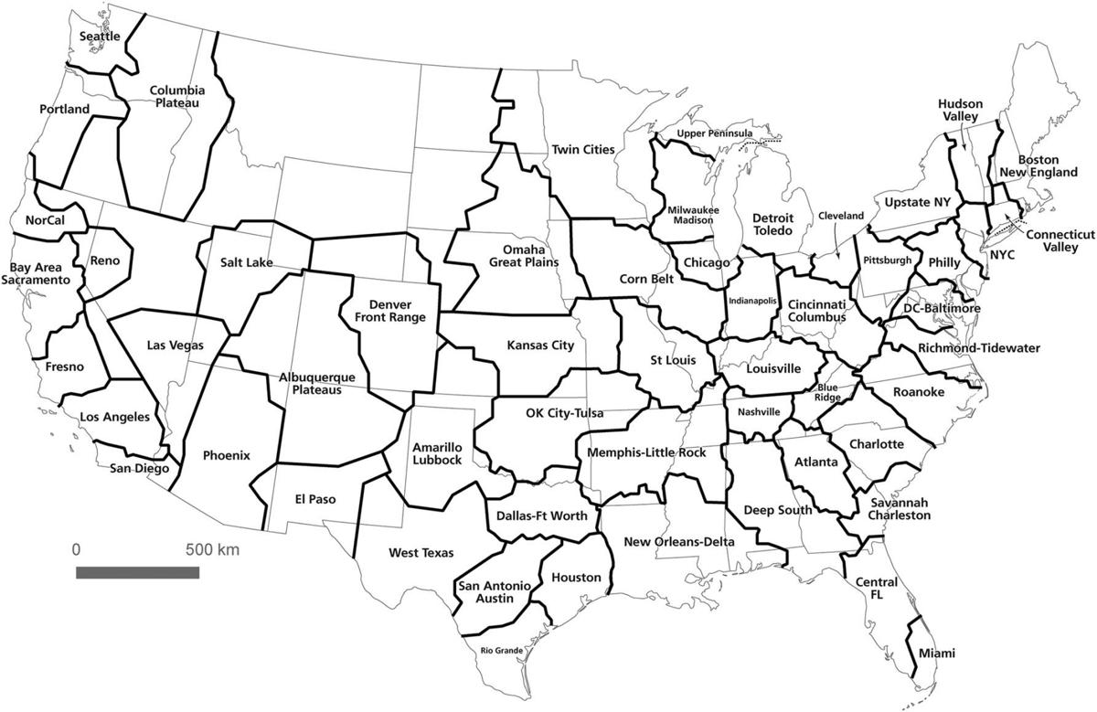
The answer is it would look a lot like the map at right.
Two researchers — geographer Garrett Nelson at Dartmouth College in New Hampshire and urban planner Alasdair Rae at the University of Sheffield in Great Britain — have been studying what the economy looks like in geographical terms. Conveniently, the federal government collects lots of data on commuting patterns. If you feed all that data into a computer and ask it (nicely) to produce a map, it will.
The result is a recently-published paper called “An Economic Geography of the United States: From Commutes to Megaregions” that shows what the nation’s economy really looks like. It’s an academic study that has some very practical applications for us here in Virginia.
Those of us in this part of the state often feel disconnected from the rest of Virginia, as the population — and the political power that goes with it — tilts increasingly toward the urban crescent. This map gives physical dimension to that feeling.
Economically speaking, the Roanoke and New River valleys aren’t connected to the urban crescent. For one thing, the urban crescent is really two different megaregions — one around Washington, the other anchored in Richmond and Hampton Roads.
For another, the map of commuting patterns shows we’re really more connected with two big metros in North Carolina — Greensboro/Winston-Salem and Raleigh-Durham. On this mythical — but mathematical — map, Nelson and Rae have even dubbed that megaregion the State of Roanoke. It’s a nice way to describe how the region really runs along the Roanoke River.
There’s a more interactive map online at http://discovery.dartmouth.edu/megaregions where you can zoom in and see outlines more clearly.
Based on commuting patterns, the dividing line for this State of Roanoke brings in Covington but not Lexington, where the commuting patterns generally lead toward Staunton, Waynesboro and Richmond. That’s not to say no one in Lexington commutes to Roanoke, but that most of them go north. To the west, our new state brings in Wytheville and Galax; the rest of Southwest Virginia belongs to an economic state that runs south to Knoxville, Tennessee.
This map brings unexpected clarity to a lot of issues the region faces.
n When Virginia was drawing lines for its new system of regional economic development boards, there were some in the Roanoke and New River valleys who resisted being included with Lynchburg. Based on commuting patterns, though, Lynchburg is more naturally connected with us than it is with points east. Drawing that border to include Lynchburg was a good call.
n We’ve been skeptical of whether Virginia really needs another layer of bureaucracy to promote economic development. However, these maps do validate one of the central points of the “GO Virginia” initiative — that there is not a single Virginia economy, but rather a collection of regional economies. Perhaps the key takeaway is how each of those regional economies crosses state lines, ours more than others.
n Since the 1990s, there’s been talk of building I-73, a new interstate to connect the Roanoke Valley to Greensboro, and points south. This new map shows more clearly just how those economic connections work. The relationship between Roanoke and Raleigh may not be readily apparent, but our commuting patterns do tie us to Greensboro — and Greensboro’s commuting patterns are very clearly connected to Raleigh, thanks to Interstate 40. It’s the old hipbone-connected-to-the-thighbone rule.
So what, if anything, should we do about this? Obviously, nobody’s going to be redrawing the actual state lines. That’s probably a good thing. North Carolina’s state government appears completely dysfunctional. We don’t want anywhere close to that. However, there might be some action items on how we think about things. That leads to what appear to be two diametrically opposite conclusions — but may not be.
We shouldn’t count on Richmond so much. We’re obviously dependent on Richmond to set tax rates and determine school funding and road funding; there’s no way to around that. But these maps should make clear: We’re in a completely different economic region, and we should act like it. If we’re going to solve the economic challenges we face — primarily slow growth and unforgiving demographics — we need to fix them ourselves. We can’t secede politically, but these maps show we already have seceded economically. We just need to secede mentally; think of it as a regional form of Brexit.
We should pressure Richmond more. These maps should help state leaders understand they’re really governing multiple states, economically speaking. What helps Richmond (or Northern Virginia) doesn’t necessarily help us. Oh, it helps in the sense that a more robust economy there generates tax revenues that might get spent here. But new jobs there don’t necessarily generate economic growth here. It’s easy for state leaders to ignore us because we’re geographically distant; these maps show it’s also easy for them to ignore us because we’re in a completely different economic ecosystem. For the things where we are forced to count on Richmond, perhaps we need to speak more loudly.
We could also start signing all our mail to Richmond with the address “The State of Roanoke.” That might get some attention.
